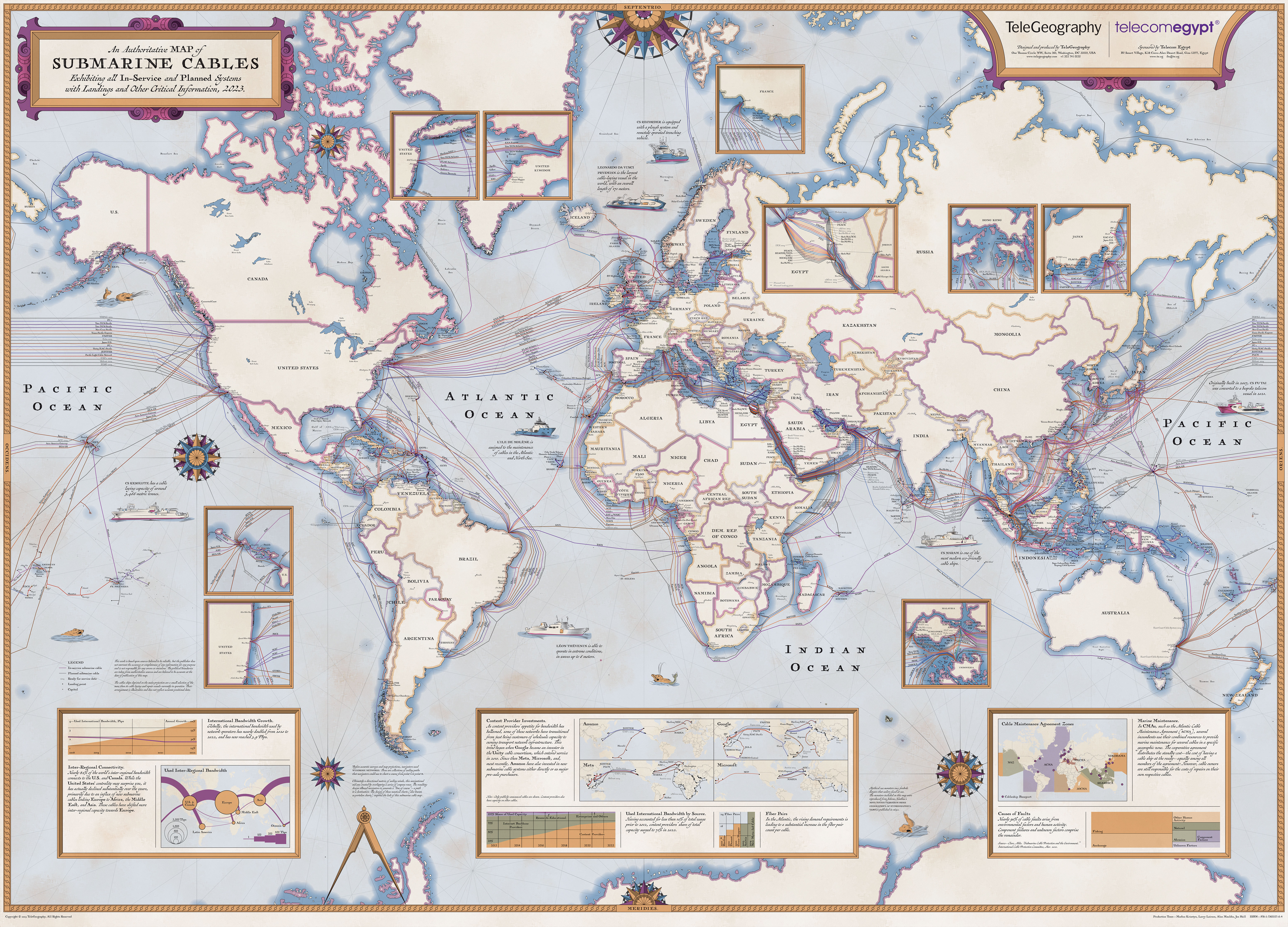
Submarine Cable Map 2023
114 points by Galacta7 1 year ago | 60 comments- Scoundreller 1 year agoThe Katittuq Nunavut Fibre Link, labelled as 2025, had its tender cancelled this year.
https://www.cbc.ca/news/canada/north/nunavut-cancels-tender-...
> Nunavut is the only province or territory in the country [Canada] without access to fibre internet. The project would bring fibre to both Iqaluit and nearby Kimmirut.
Right now, everything is over satellite. Too bad the big "internet cache" systems don't have sneakernet approaches to filling their caches. Unsure if their local ISP does any kind of caching. So every stream/download/update, etc. is its own "hit" over the downlink.
Thanks to Canada's terrible mobile telecom pricing and lacklustre competition, a cell phone with a dataplan in this territory is cost-competitive with the rest of the country...
- betaby 1 year agoThe whole territory of Nunavut is under 40k habitants. It's totally fine to serve it with satellite. Also I don't see how any completion is possible, again, for a territory with under 40k habitants.
- betaby 1 year ago
- nemoniac 1 year agoSome years ago I visited the Transatlantic Cable Station on Valencia Island off the west coast of Ireland, from where the first submarine telegraph cable was laid to Newfoundland in 1857. After several attempts the cable reached Newfoundland in 1866.
Before that moment the fastest way to get a message from Europe to America was aboard a ship; two weeks or so. After that it could be sent over a cable with Morse code.
https://valentiaisland.ie/valentia-transatlantic-cable-stati...
- _whiteCaps_ 1 year agoIf this sort of thing interests you, I highly recommend "Mother Earth Mother Board" by Neal Stephenson. Probably my favourite piece of writing in Wired.
- Kim_Bruning 1 year agoThere's a rotating sphere at the top of the map, but part of it is black, and apparently you're not supposed to use it? It's just decoration?
You scroll down to what you think is the map, but it immediately gets covered by a caption, so you scroll down more ...
It turns out that downloads for the actual map are at the top of the page.
- FL410 1 year ago...but only after you scroll all the way to the bottom. What a horrible design.
- Tempest1981 1 year agoYeah, very frustrating to see just the Pacific Ocean w/o text blocking half of it.
Fortunately mmwelt posted another link for exploring:
- joering2 1 year agoCame here to say the same. And clicking on the globe does not stop it. Then trying to zoom and you can't but the globe image is too blurry/low res to read what's on it. Don't get me even started on scrolling...
- Tempest1981 1 year ago
- FL410 1 year ago
- ezequiel-garzon 1 year agoI love these maps, and I'm glad they provide downloads like [1]. I wish the resolution was a bit higher. As it is the names of the towns on the coasts can be read with difficulty.
[1] https://submarine-cable-map-2023.telegeography.com/images/Su...
- dotancohen 1 year agoWow, that map is very political. Israel is not mentioned by name, but the Palestinian Territories are.
- josh_frome 1 year agoTelecom Egypt is the sponsor of the map
- jacooper 1 year agoSo writing Israel isn't Political? Your definition of political is obviously biased.
- dotancohen 1 year agoWould writing Germany be Political? Writing Ukraine? These nations exist and are functioning parts of international relations.
- dotancohen 1 year ago
- Kye 1 year agoThere is no selection of labels for disputed territory that will make everyone happy. It's inherently political.
- dotancohen 1 year agoWith the exception of the ambitions of fringe terrorist groups, the land that Israel has ruled since 1948 is not disputed territory.
- dotancohen 1 year ago
- h0nd 1 year agoMaybe to avoid politics, the name of the region was used.
- dotancohen 1 year agoThat would have been an acceptable explanation in the 1950s or early 60s. But after 1964 one of the sides adopted the regional name as a national identifier, thus invalidating it as a neutral name.
- dotancohen 1 year ago
- josh_frome 1 year ago
- mikae1 1 year agoToo bad it's a rather shitty JPEG that's blotchy in the more uniform "white" areas. I've been able to compile a map from the png tiles for the earlier versions of this map.
It uses mapbox.js and tiles have URLs like this one: https://tiles.telegeography.com/maps/submarine-cable-map-202...
https://dezoomify-rs.ophir.dev/ is helpful.
- dotancohen 1 year ago
- mmwelt 1 year agoThe interactive online version is available here:
- h0nd 1 year agoI was looking for this as I was surprised that a map would be displayed the way it is in the shared link.
- Tempest1981 1 year agoMuch better, thank you.
- h0nd 1 year ago
- jedberg 1 year agoGiven all the compute infrastructure in Ireland, I'm surprised it still has no direct connection to continental Europe (they all go through the UK first).
- Scoundreller 1 year agoI wonder if they put in a "long-way-around" splice into these forks in the Atlantic, so Ireland would have a connection to Denmark:
https://www.submarinecablemap.com/submarine-cable/havfrueaec...
Then you've got this link to the SW tip of UK, that then links to France (via Guernsey & Jersey): https://www.submarinecablemap.com/submarine-cable/pan-europe...
There might be an overall direct fibre link.
But yeah, Ireland is at risk of the UK cutting most of their continental Europe capacity.
I've seen some strange investments though that don't seem to add much more on top of what's already there, like this company's: https://crosslakefibre.ca/network/ But maybe despite ample existing infrastructure, the incumbent providers suck so they can make a successful go at providing a bypass.
- SnorkelTan 1 year agoThe reduction in latency and additional throughput is probably not worth the cost. I’m sure the cable operators have considered this.
- Scoundreller 1 year ago
- zrail 1 year agoHow do these cables split in the middle of the ocean? Is there a fiber switch laying on the ocean floor?
- rdl 1 year agoThere are repeaters on the cable every ~50-200km (depending on technology), powered by DC power carried on the cable. There are branching units powered the same way -- I believe they handle branching at the fiber level, rather than waves, but not sure of the specifics on modern DWDM cables. (they can run ~80-160 different frequencies of light on the same fiber, and the cables contain multiple fibers...)
- aDfbrtVt 1 year agoQuick correction - not repeaters but amplifiers. The term repeater is commonly used to refer to a device that demodulates and remodulates a signal.
- aDfbrtVt 1 year ago
- Maakuth 1 year agoNo idea of what precise sort of hardware is there, but the fact is that these cables consist of a bunch of fibers. Dozens of them typically, quick search suggests up to 144, but I doubt that's a physical ceiling. So I suppose they make a branch when needed, with some number of fibers going to another direction.
- rdl 1 year ago
- ThinkBeat 1 year agoIs it safe to assume that there exists a lot of cables that we are not supposed to know about or at least that are not public and not on such amps?
I have long been thinking that the NSA must have some high capacity "black" cables to help the surveillance of the internet. Primarily to capture data, sending all the captured data back through the public internet would be counterproductive.
A 5eye private subsea network?
I would assume other countries have some for similar reasons
- dmvdoug 1 year agoWell, SOSUS had cables that people knew fed into landing stations on the coast but what exactly they were for remained classified until like the 1980s. So those are literally classified government cables. If you mean secret Internet cables, I have no clue, but hey, history teacher had a history answer so… hi. :)
- dmvdoug 1 year ago
- sklargh 1 year agoDoes anyone else find it a little weird that the Great Salt Lake is shown on the map but Lake Champlain and Lake of the Woods are not?
- dotancohen 1 year agoI just noted in another comment how the map is very political in its choice of things to label.
- dotancohen 1 year ago
- ericra 1 year agoIt's amazing how many cables there are routing through the Suez Canal, especially directly connecting Mumbai all the way through to Marseille.
I wonder how well protected they are specifically in the Suez Canal. Presumably the whole area is pretty well surveilled by the Egyptian government, but I have no clue. I just think it's really interesting how many cables are (understandably) routed this way and wonder whether there is full backup redundancy in the few cables running around south of Africa.
- 082349872349872 1 year agoI was initially surprised by how highly the cable map correlates with canonical surface traffic routes, but upon reflection I guess the basic economics of trade centres drives both, so I should've expected it...
- 082349872349872 1 year ago
- badrabbit 1 year agoIf fiber cables like these are possible, why not pneumatic tubes maybe 1 meter in diameter. Think of the economic and environmental implications!
- analog31 1 year agoThe pressure.
- analog31 1 year ago
- gist 1 year agoWell a random check of one cable (Gemini Bermuda) shows it was decommissioned in 2004. I wonder how up to date the rest is (based on this one entirely random check).
https://en.wikipedia.org/wiki/Gemini_(submarine_communicatio...
- huytersd 1 year agoSo is dijibouti some massive switching station hub or do those cables just go by it underwater?
- toast0 1 year agoMy understanding is most of the multipoint cables are not switched at every point, it's more of a bundle of cables where each point gets a strand or two to every other point (or selected points, maybe the anchor points connect to all others, but minor points might only connect to the anchors and not each other).
That said, Djibouti is a major cargo transport hub for Ethiopia, and is probably a network transport hub as well. Ethiopia is the 2nd most populated country in Africa and that would justify a lot of cable landings.
- toast0 1 year ago
- davedx 1 year agoIf the world could run power along all these submarine telecoms cables then we'd be a lot further towards solving the problem of renewable power generation. I wonder how these kinds of cables compare to HVDC cables in terms of size and cost.
- ccakes 1 year agoThey do, any cable over about 1000km has active repeaters on the seabed which need to be powered.
There is HVDC equipment on both ends and typically each end is sufficient to power the entire cable independently to allow for the cable to continue running through maintenance, shunt faults (basically something earthing out on sea water) or a single failed repeater.
- ccakes 1 year ago
- 1 year ago
- tiahura 1 year agoI'm not seeing my favorite, Honotua. It connects Hawai'i to Tahiti. https://en.wikipedia.org/wiki/Honotua
- cliffordc 1 year agoIs there somewhere we can see submarine and land cables both?
- ivix 1 year agoLand cables are usually considered classified/sensitive information, so no not generally.
- ivix 1 year ago
- ris 1 year agoDear map widgets in 2023,
Stop asking me for WebGL, I will not give it to you.
- rmah 1 year agoIt's interesting how Europe-Asia interconnects are so small relative to US-Asia and US-Europe.
- jedberg 1 year agoThis is only undersea cables. Europe and Asia have overland connections too. But mostly it's because both continents do more business over the internet with the US than with each other.
- jedberg 1 year ago
- everybodyknows 1 year agoAre any of the spatial datasets that may have gone into this available for public download?
- Thaxll 1 year agoI mean the website is crap, how do I see the map as a whole?
- Galacta7 1 year agoTry this link instead: https://www.submarinecablemap.com/
- Galacta7 1 year ago
- maxlin 1 year agoThis has to be the worst possible way to present this. Just give us a, you know, MAP. With openable annotations and panning so we aren't locked in some view we didn't navigate to with tons of info about something we didn't actually seek out.
- vikmals 1 year agoDoesn't work
- xkekjrktllss 1 year agoI have a 5k display and I can't even quite make the page wide enough to view the entire globe. How are people with regular displays supposed to view it? What a disaster of a presentation!
- mikae1 1 year agoIt's meant to be printed. https://www.submarinecablemap.com is for screen viewing.
- ponector 1 year agoDisaster is to read this site from phone. It is horrible.
- mikae1 1 year ago
- aaron695 1 year ago[dead]